Day 1
Walking Waterways; Wherries and Weavers
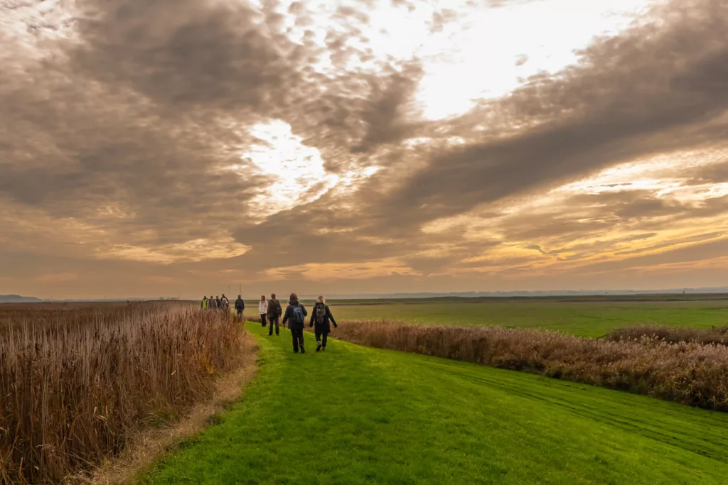
Norfolk is not normally considered the first choice when considering industrial archaeology, but you would be wrong. This walk takes you to some stunning natural wetland landscapes, but there is also wealth of Industrial archaeology hidden in plain sight. To the north of Wayford Bridge the old course of the River Ant has been straightened and canalised in part, forming a section of the North Walsham and Dilham Canal, Norfolk’s only true canal. The canal which opened in 1826, was nearly 9 miles long, and extended as far as Antingham Bone Mills. The Norfolk wherries used to ply their trade along the canal, sadly no longer, but these historic boats with sails hoisted can still be seen elsewhere in the broads if you are lucky.
The canal had six locks with Lock No 1 at Honing, now the furthest extent of water access for canoes and small craft. The main function of the canal was to improve the navigation for the wherry trade which served the farms and a series of watermills connected to the River Ant from Dilham northwards.
As well as Honing lock, walkers can also cross this southern section of the canal at historic Tonnage Bridge. The bridge partly collapsed in 1980 but has been rebuilt.
The canal suffered commercially following the building of the Great Yarmouth to North Walsham railway. Early schemes to encourage leisure use were unsuccessful. By 1923 traffic had reduced to six wherries and by the early 1930s there was only one, the ELLA, which last used the canal in 1934. The disused route of the railway crosses this area and now forms part of the long-distance Weavers’ Way footpath. The line of the route has now naturalised to the extent that it is hard to imagine it as a railway line, however a crossing keeper’s cottage and other traces of railway archaeology offer clues to its former use.
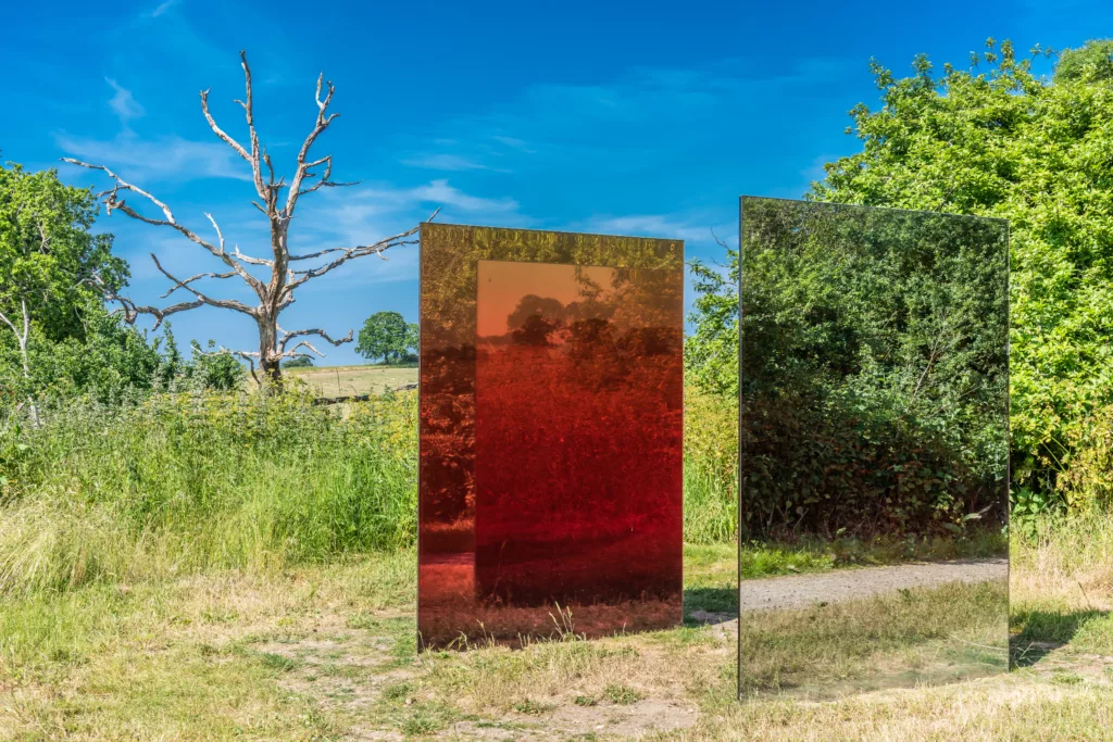
Honing Passage by Studio Sabine at Honing Station
Part of the Norfolk Way Art Trail, Honing Passage by Studio Sabine, is created from two offset glass surfaces that reference the history of the area and the movement of railway carriages that used to travel on nearby tracks. Forming a void, the space between the panels, or ‘passage’, is designed to encourage interaction from visitors, as they are invited to fully immerse themselves in colour and reflection. A unique place for the community to interact, reflect and enjoy nature, the passage embraces the beauty of the local landscape, framing the surroundings through a unique lens.
Community photography workshops were held around the Honing Station area by the Norfolk-based photographer, Debby Besford. Participants were invited to take photos of the beautiful natural bright colours that they encountered along the tracks of the old railway line. A photograph from the workshops, selected by the artists, has been used to inform the colour palette of the final design of Honing Passage.
Outside of the passage, the mirrored surfaces reflect their environment without alteration, seamlessly blending the piece into nature. Inside, the walls act as lenses, filtering all it reflects through layers of colour.
The artwork is activated by the seasons, offering a new way to look at the natural site and its ever-changing state. Its vibrant colours are taken from photographs of the area by members of the community and offer a great contrast with the site, especially during the winter season.
The other artworks which form the Norfolk Way Art Trail are Iron Reef at Reedham Ferry Inn, Flock at Diss Mere, Interval at Eastbourne Place in Norwich and Flint at Norwich Arts Centre
Day 2
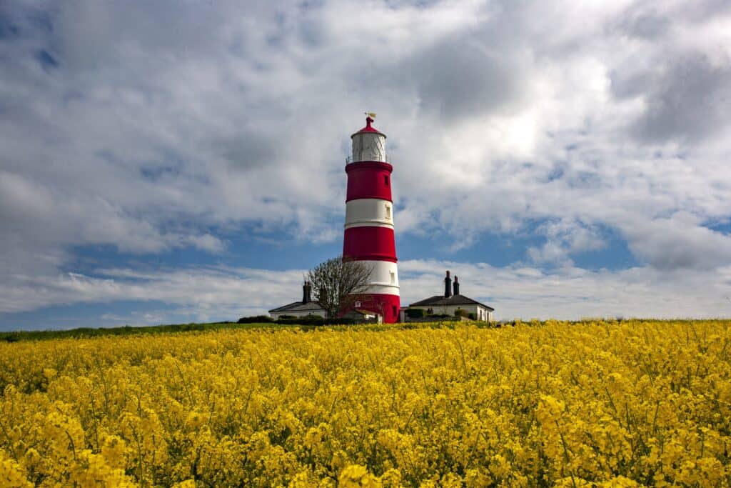
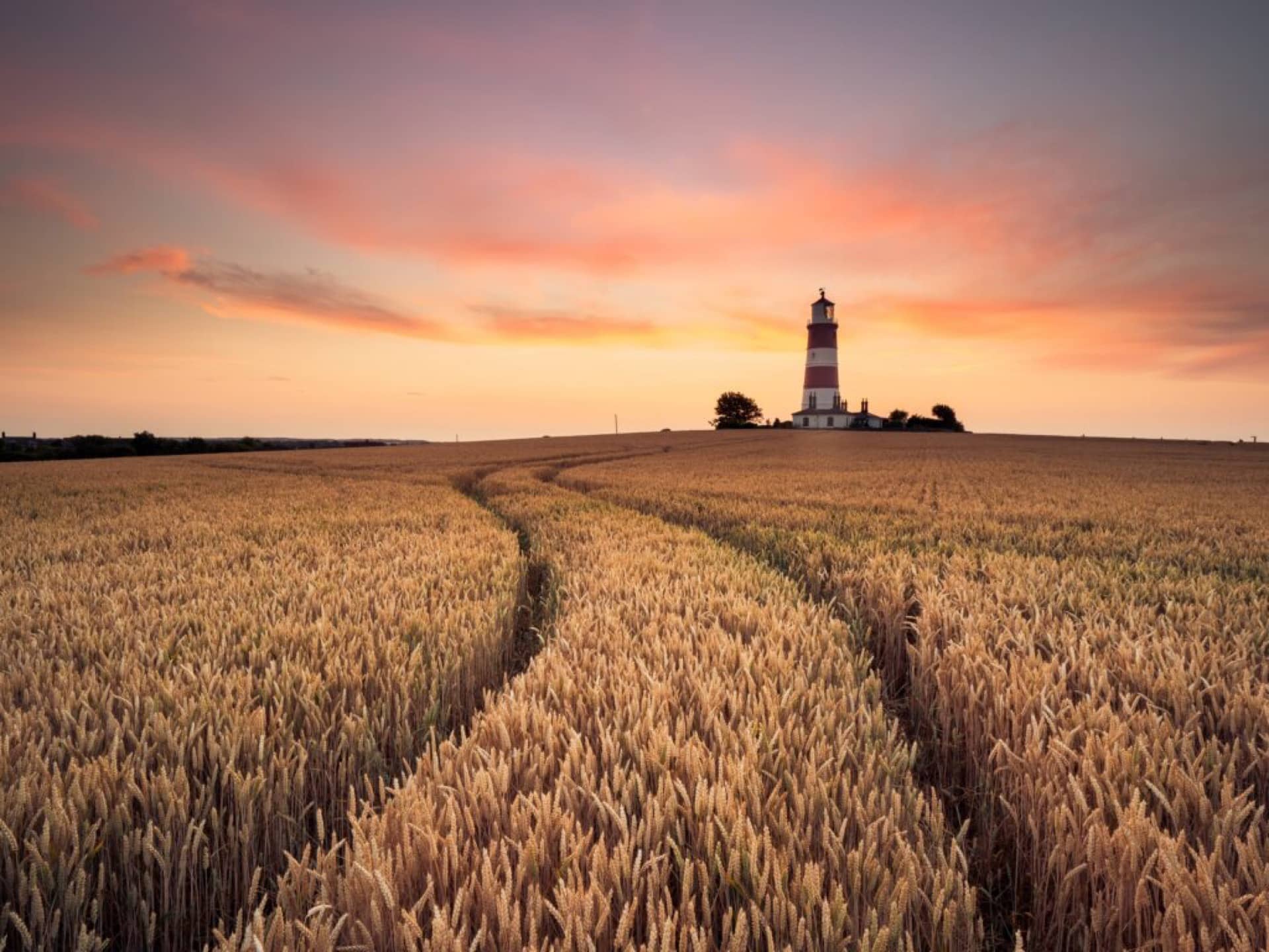
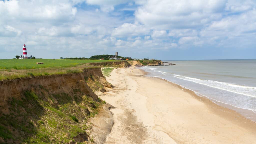
Happisburgh Lighthouse
On the east coast of Norfolk stands an enigmatic lighthouse. Facing the sunrise, it sits proudly on Happisburgh’s soft sandy cliffs where each morning the first rays of light catch the colourful facade, bathing its red and white stripes in the orange glow of a new day. This photogenic landmark was built in the wake of a terrible tragedy. In 1789 a terrible storm blew up. 70 sailing ships were wrecked in the crashing waters and 600 men lost their lives. The subsequent enquiry drew attention to the lack of warning lights between Cromer and Winterton so in 1791 two lighthouses were constructed. The ‘Low Light’ is now demolished but the ‘High Light’ is the distinctive tower that survives today. Once the ‘Low Light’ had gone, during daylight it was necessary to distinguish the Happisburgh lighthouse from the tower at Winterton and so three spectacular broad red bands were painted on the Happisburgh tower, just as you see today.
In 1987 Happisburgh Lighthouse was one of five lighthouses declared redundant with decommissioning scheduled for summer 1988. But local people were not going to allow their beloved lighthouse to be torn down! They mobilised and in 1990 a Private Bill was granted Royal making Happisburgh Britain’s only independently operated working lighthouse. It’s also the oldest working lighthouse in East Anglia, looked after by the Happisburgh Lighthouse Trust. It’s fascinating to look inside so if you can’t make one of the set open days, contact them to arrange a private visit.
The Legless Ghost of Happisburgh
Happisburgh is a place of shifting boundaries, land and sea, time and space, life and death. Even the name changes, depending on where you’re from. Those in the know say ‘Haze-burr’, anything else just sounds strange. And talking of strange things, here’s a gruesome ghost story for winter nights.
There were once some farmers heading home for supper and a flagon of ale. Near Cart Gap they saw a figure lurching towards the village, clutching a filthy sack. He seemed to be a poor hunch-backed sailor but something was very wrong. Peering through the gathering dusk the farmers were struck with sickening horror. That was no hump, but a nearly severed head, hanging by a single ribbon of flesh, thudding against the spectre’s spine as it walked. Yet how did it walk? For the grisly creature had no legs!
Terrified, the farmers hotfooted it to the inn. (We’d wager the phantom wasn’t the only one completely legless that night!) After more sightings, the gruesome ghost was followed to the grassy triangle where Whimpwell Street meets Whimpwell Green and Coronation Road. There it vanished into a well. A brave young man lowered himself down, groping in the gloom. There was the sack! And inside were sailor’s boots…with sailor’s legs still inside! The well was drained. And there was another sack, containing a torso in sailor’s uniform, its hideous skull dangling by a strip of rotting flesh.
Smugglers’ tale or true? We dare you to investigate…
Walking Through Time
Walkers love Norfolk’s stunning coastal paths. If you’re one of them, you’ll be following in the footsteps of people who’ve walked here for hundreds of thousands of years.
In fact, actual footprints were discovered at Happisburgh, left in the ancient estuary mud by people roaming this land before the Ice Age. Over 850,000 old, it’s possible they were made by nomadic hunters, following migratory animals such as mammoths, bison, rhinos and deer in the days when Britain was connected to mainland Europe by a great plain, similar to East Africa’s Serengeti. Or perhaps searching the mudflats for seaweed and shellfish.
Amongst the earliest evidence of humans in Britain, these amazing footprints were found accidently during a geophysics survey in 2013. Around 50 footprints were discovered, two showing details of toes. Approximately five individuals were identified, both adults and children. Their footprints were carefully photographed in 3D before being washed away forever by the tides of the North Sea, lost deep in time.
The course of the river where our ancestors once walked has now moved south and is today known as the Thames. Standing on the flint shingle banks, imagine the rolling waves as a vast flowing grassland of creeks and scrub allowing direct passage from Norfolk all the way to Africa.
Close your eyes and listen intently. The hyena and bison have long gone, but sometimes the sea sounds like swishing grass and wind like the mournful trumpet call of a mammoth.
Build your own itinerary
If you fancy creating your own itinerary for a day trip to Norfolk or a longer visit, it couldn’t be simpler. Just go to Search Activities and select from our wide range of free and paid-for experiences, saving any that capture your imagination with the click of a button.
Once you’ve finished, you’ll find all the information stored in My Favourite, where you can drag and drop activities to create your own day-by-day itinerary! You can download this to a calendar and even share it with friends.